BEIDOU GLOBAL NAVIGATION SATELLITE SYSTEM

ABOUT Beidou
The concept for a Chinese Regional Navigation System was first introduced in 1983. In 1989, the system using two geostationary satellites (code name: Twinsat) passed in-orbit validation. The experiment was conducted on two DFH-2/2A communications satellites that were already in orbit.
The first stage of the BeiDou system (BeiDou – "Northern Dipper", the Big Dipper constellation) began in 1994. Two geostationary satellites were launched in 2000: BeiDou-1A (October 30, 2000) and BeiDou-1B (December 20, 2000). The BeiDou-1 satellites were based on the DFH-3 geostationary communications platform. On 15 December 2003, the first generation BeiDou system was successfully put into operation. The launch of the third BeiDou-1C geostationary satellite in 2003 improved the performance of the system.
The development of the second-generation BeiDou system, BeiDou-2, began in 2004. By the end of 2012, 14 new satellites (5 geostationary satellites, 5 satellites in inclined geosynchronous orbit and 4 satellites in medium orbits) were launched to complete the orbital constellation. BeiDou-2 was designed to be compatible with BeiDou-1 and provide users in the Asia-Pacific region with positioning, velocity, time, wide-area differential corrections and short message services.
The development of the third-generation BeiDou-3 system began in 2009. The main purpose is to provide basic services to users on the territory and water area of both Silk Roads (land and water) and surrounding regions, and to complete the deployment of the 35-satellite orbital constellation designed to provide global user services.

Beidou services
After the deployment of the Beidou-3 constellation, the system provides the following services:
- global basic open service,
- augmentation system services (wide-area satellite-based augmentation system service and ground augmentation system service),
- short message communication services (global and regional),
- Precise Point Positioning service,
- Search and Rescue service.
ORBITAL CONSTELLATION
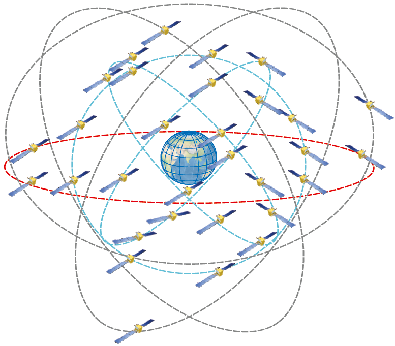
BeiDou-3 constellation is a mixed one consisting of 30 operational satellites in three types of orbits: medium Earth orbits, geostationary orbit, inclined geosynchronous orbits.
| 3 satellites in geostationary orbit (GSO) | Orbital slots | 80°E, 110.5°E, 140°E |
| Orbital altitude | 35 786 km | |
| 24 24 satellites in medium Earth orbits (MEO) | Number of orbital planes | 3 |
| Orbital inclination | 55° | |
| Orbital altitude | 21 528 km | |
| Orbital period | 12 h 53 min 24 s | |
| 3 satellites in an inclined geosynchronous orbit (IGSO) | Equator crossed by the satellites ground tracks at 118°E. | |
| Orbital inclination | 55° | |
| Orbital altitude | 35 786 km | |
TYPES OF SATELLITES
 |
||
CHARACTERISTICS |
GEO AND IGSO SATELLITES |
MEO SATELLITES |
|---|---|---|
| Prime | Chinese Academy of Space Technology (CAST) | Chinese Academy of Space Technology (CAST) |
| Satellite platform | DFH - 3/3B | DFH - 3B |
| Lifetime | ~ 15 years | ~ 10 years |
| Weight | 828 kg | 850 kg |
| Frequency bands of open signals | L1 (B1) L2 (B3) L3/L5 (B2) |
L1 (B1) L2 (B3) L3/L5 (B2) |
| Onboard atomic frequency standard | 2 Rb (manufactured in China) | 2 Rb (manufactured in Europe) |
| Additional capabilities | Laser retroreflectors Cosmic ray detectors |
Laser retroreflectors Cosmic ray detectors |
NAVIGATION SIGNALS
BeiDou-2 satellites transmit three open signals – B1I signal with a carrier frequency centered at 1561.098 MHz, B2I signal (1207.140 MHz) and B3I signal (1268.520 MHz). With the same central frequencies, three signals of restricted access are transmitted.
User positioning error utilizing Beidou-2 satellite signals is less than 5 m (4.6 m in dual frequency mode).
BeiDou-3 satellites transmit five open signals – B1I, B3I, B1C, B2a and B2b. Three of them (B1I, B2b and B3I) have the same carrier frequencies as the BeiDou-2 signals.
Two other open Beidou-3 signals (B1C and B2a) are in the so-called "international" bands – the carrier frequency of B1C signal (1575.42 MHz) coincides with the carrier frequency of L1C GPS and E1 Galileo signals, while the carrier frequency of B2a signal (1176.45 MHz) coincides with the carrier frequency of L5 GPS and E5a Galileo. These signals were developed by China after many years of consultations with the United States and the European Union. Compatibility of these BeiDou signals with GPS and Galileo signals is achieved by using different types of modulation.
In addition to open signals, Beidou-3 transmits three signals of restricted access – B1A, B3Q and B3A.
BEIDOU NAVIGATION SIGNALS SPECTRUM

CHARACTERISTICS OF BEIDOU-3 SIGNALS
| Band | Carrier frequency, MHz | Signal | Ranging code length, chips |
Chip rate of ranging code, Mc/s | Type of modulation | Data rate, bit/s |
|---|---|---|---|---|---|---|
| B1(L1) | 1 575.42 1 575.42 1 561.098 |
B1C B1C-SBAS B1I |
10 230 (primary) 1 023 2 046 |
1.023 (primary) 1.023 2.046 |
BOC (1, 1) BPSK (10) BPSK (10) |
100 500 50(D1)/500(D2) |
| B2(L3) | 1 176.45 1 207.14 1 207.14 |
B2a B2b B2b-PPP |
10 230 10 230 10 230 |
10.23 10.23 10.23 |
BPSK (10) BPSK (10) BPSK (10) |
200 1000 1000 |
| B3(L2) | 1 268,52 | B3I | 10 230 | 10.23 | BPSK (10) | 50(D1)/500(D2) |
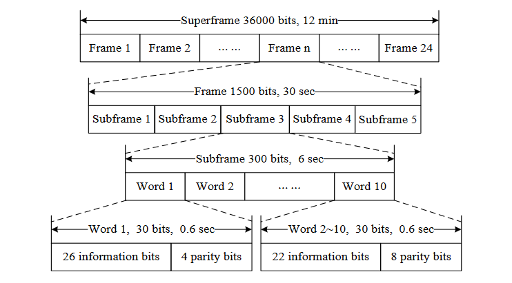
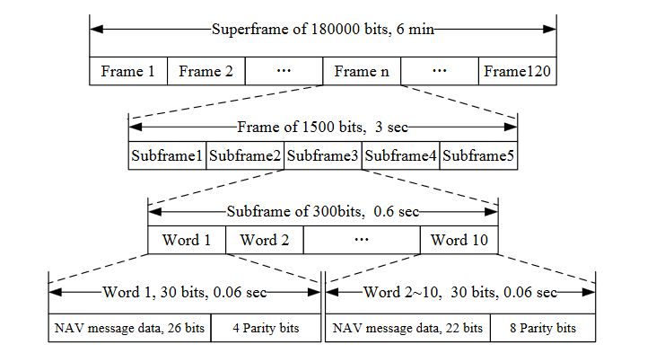
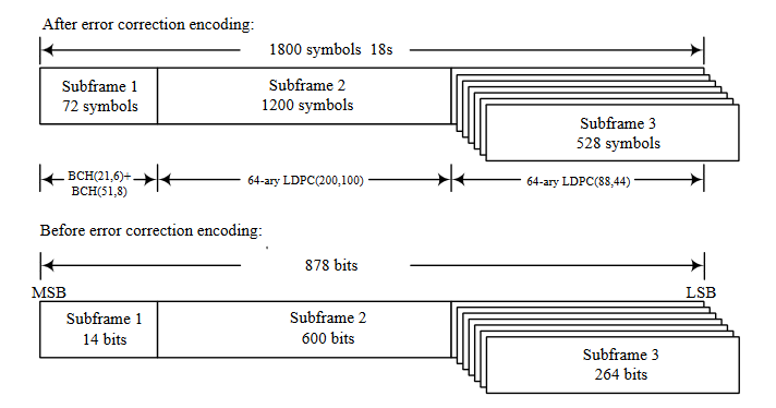
BEIDOU NAVIGATION MESSAGE STRUCTURE
GEODETIC REFERENCE SYTEM AND TIME SCALE
REFERENCE SYSTEM
BeiDou satellites orbit parameters are transmitted utilizing the BeiDou Coordinate System (BDSC) that is consistent with CGCS2000 (the China Geodetic Coordinate System 2000), both reference systems have the same ellipsoid parameters. Its origin is at the center of mass of the Earth. Its Z-axis directs from the origin to the Reference Pole of the International Earth Rotation Service (IERS Reference Pole). Its X-axis directs from the origin to the intersection of the IERS Reference Meridian and the plane normal to Z-axis. Its Y-axis completes the right-handed orthogonal coordinate system.
| Parameters | value |
|---|---|
| Semi-major axis, m | 6378137,0 |
| Geocentric gravitational constant (the mass of the Earth’s atmosphere included), m3/s2 | 398600,4418 * 109 |
| Earth’s rotation velocity ω, rad/s | 7,2921150 * 10-5 |
| Flattening | 1/298,257222101 |
TIME SYSTEM
The BeiDou System Time (BDT) is adopted by the BDS as time reference based on the atomic frequency standard of the System Control Center in Beijing. BDT is a continuous time scale connects with UTC via UTC (NTSC), and the deviation of BDT to UTC is maintained within 50 nanoseconds. BDT start epoch is 0:00 of January 1, 2006 of UTC. It is envisaged to broadcast offsets between BDT and GPS Time, GLONASS Time and Galileo Time in BeiDou navigation signals.
GROUND CONTROL SEGMENT
The ground control complex of the BeiDou system includes several Master Control Stations (MCS), Uplink Stations (US) and the global network of Monitoring Stations (MS).
There is no detailed information on the number and specialization of the stations according to their functional purpose in open sources.
It is worth noting the involvement of the China’s Navy in tracking the satellites, especially during the phase of placing in orbit and initial operations.
The BeiDou program high-ranking management acknowledges the need to expand the network of Monitoring Stations beyond the territory of China.
INTERFACE CONTROL DOCUMENT
BeiDou Interface Control Document: http://en.beidou.gov.cn/SYSTEMS/ICD/
OFFICIAL WEBSITE
BeiDou User Information Center: http://www.en.beidou.gov.cn/


 Стандарт эксплуатационных характеристик открытого сервиса
 Принципы навигации
 Ионосфера
 Испытания НАП, оценка условий спутниковой навигации