About GLONASS

The first proposal to use satellites for navigation was made by V.S.Shebashevich in 1957. This idea was born during the investigation of the possible application of radio-astronomy technologies for aeronavigation. Further investigations were conducted in a number of the Soviet institutions to increase the accuracy of navigation definitions, global support, daily application and independence from weather conditions. The research results were used in 1963 for R&D project on the first Soviet low-orbit “Cicada” system. In 1967 the first navigation Soviet satellite "Cosmos-192" was launched. The navigation satellite provided continuous radio navigation signal transmission on 150 and 400 MHz during its active lifetime.
The “Cicada” system of four satellites was commissioned in 1979. The navigation satellites were placed into circular orbits 1,000 km high with an inclination of 83 ° and equal distribution of orbital planes to the equator. It allowed users to acquire one of the satellites every hour and a half or two and fix the position within 5-6 min of a navigation session. The navigation system “Cicada” used one-way user-to-satellite range measurements. Along with improvement of the satellite onboard systems and navigation equipment much attention was given to enhancing accuracy of determining and predicting parameters of the navigation satellite orbits.
Later, receiving measuring equipment was disposed on the “Cicada” satellites to detect distress radiobeacons. The satellites received these signals and rebroadcast them to special ground stations where the computation of the exact coordinates of the emergency objects (ships, aircraft, etc.) was held. The “Cicada” satellites tracking distress radiobecons formed “Cospas” system that together with the US-French-Canadian "Sarsat" system built an integrated search and rescue service that saved several thousands of lives. The “Cicada” space navigation system (and its “Cicada-M” modernization) was designed for navigation support of military users and had been in use since 1976. In 2008 “Cicada” and “Cicada-M” users started to use GLONASS system and the operation of those systems was halted. It was impossible for the low-orbit systems to meet requirements of a great number of users.
Successful operation of the low-orbit satellite navigation systems by the marine users attracted widespread attention to satellite navigation. A general-purpose navigation system was needed to meet the requirements of the great majority of prospective users.
Based on the all-round research it was decided to choose the orbital constellation consisting of 24 satellites equally distributed in three orbital planes inclined at 64.8° to the equator. The GLONASS satellites are placed in roughly circular orbits with the nominal orbit altitude 19,100 km and an orbital period of 11 hours, 15 minutes, 44 seconds. Due to the period value it became possible to create a sustainable orbital system that unlike GPS does not require supporting correcting pulses during its active lifetime. The nominal inclination ensures global availability on the territory of the Russian Federation even when several SVs are not operational.
Two challenges have been faced for designing a high-orbit navigation system. The first one dealt with mutual synchronized satellite timescales with the accuracy of billionths of a second (nanoseconds). It became possible because of high-orbit onboard caesium frequency standards with nominal stability at 10-13 and ground hydrogen frequency standard with nominal stability at 10-14 and also because of ground facilities of time scale comparison with error of 3-5 ns. The second challenge addressed high-precision determination and prediction of navigation satellite orbit parameters. This issue was solved with scientific research on second order factors of infinitesimals, such as light pressure, irregularities of the Earth rotation and polar motions and etc.
Flight tests of the Russian high orbit satellite navigation system, called GLONASS, were started in October, 1982 with the launch of “Kosmos-1413” satellite. The GLONASS system was formally declared operational in 1993. In 1995 it was brought to a fully operational constellation (24 GLONASS satellites of the first generation). A great drawback that should have been focused on consisted in the lack of civil navigation equipment and civil users.
Reduction in funding for space industry in 1990 led to degradation of the GLONASS constellation. In 2002 the GLONASS constellation consisted of 7 satellites that was insufficient for navigation support of the Russian territory even with limited availability. GLONASS was behind GPS in accuracy characteristics, SVs active lifetime comprised 3-4 years.
Things improved when the federal program "Global Navigation System for 2002-2011" was adopted and launched in 2002.
Throughout this federal program the following results were achieved:
- The GLONASS system was preserved, modernized and became operational consisting of “GLONASS-K” satellites. Nowadays there are two existing operational global navigation satellite systems: GPS and GLONASS
- Ground control segment was modernized that together with the orbital constellation ensures the accuracy characteristics at a level commensurate with those of GPS
- The State Standard of time and frequency facilities and the Earth rotation parameters definition facilities were modernized
- GNSS augmentation prototypes, great amount of patterns of core receiving and measuring modules, PNT equipment for civil and special use and related systems were designed
Nowadays there is an increasingly broad range of GNSS technologies applications. To meet user requirements it’s necessary to keep on improving the GLONASS system as well as user navigation equipment. In the first place it applies for high precision GLONASS applications where real-time accuracy at a level of a decimeter and a centimeter is necessary. It also relates to applications dealing with safety and security by air, sea and ground transport operation. Greater operational efficiency of navigation solutions and GLONASS interference resistance are needed. There are a significant number of special and civil applications where the small size and high sensitivity of navigation receiving equipment is crucial.
To solve new tasks in new conditions according to the Governmental Decree #189 dated March 3, 2012 in 2012 new federal program “GLONASS Sustainment, Development and Use for 2012-2020” was launched.
Starting from 2012 the GLONASS system has been moving in the direction of efficient PNT task solving for the benefit of defense, security and social and economic development of the country in the near and distant future.
The new federal program considers the following:
- GLONASS support with ensured performances on a competitive level
- GLONASS development towards capability enhancement aimed at achieving parity with international navigation satellite systems and leadership of the Russian Federation in satellite navigation
- GLONASS use both on the territory of the Russian Federation and abroad
The level of GLONASS capability enhancement is determined by a range of development directions the main of which are as follows:
- Development of the GLONASS orbital constellation structure
- Transition to use navigation satellites of the new generation “GLONASS-K” with enhanced capabilities
- GLONASS ground control segment development including GLONASS orbit and clock segment enhancement
- Augmentations design and development:
- The System of Differential Correction and Monitoring
- Global system of high precision definition of navigation and orbit and clock information in real time for civil users
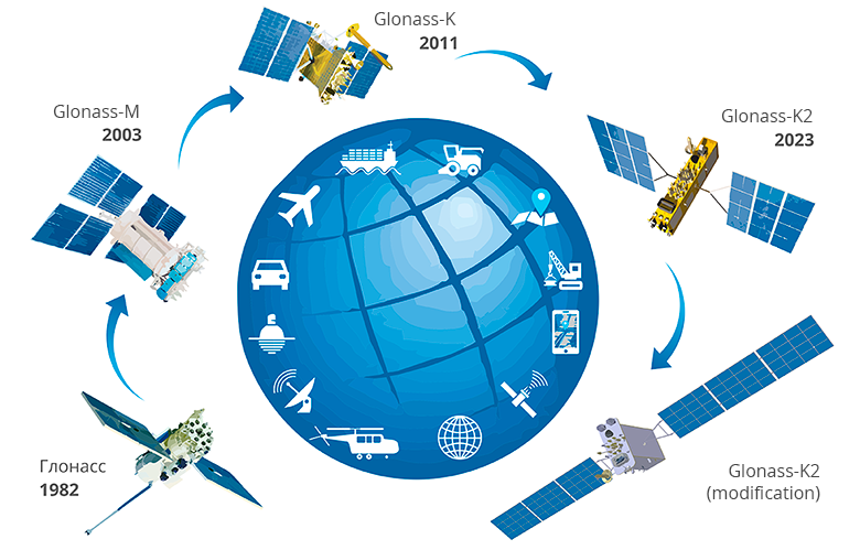
The GLONASS system development for the benefit of the increasing users requirements and competitiveness of the system is mostly determined by capabilities of the GLONASS space segment. Capability enhancements through GLONASS satellites generations are listed in the table below.
Capabilities |
Glonass |
Glonass-M |
Glonass-K |
Glonass-K2 |
|---|---|---|---|---|
| Time of Deployment | 1982-2005 | 2003-2016 | 2011-2018 | 2017+ |
| Status | Decommissioned | In use | Design maturation based on in-orbit validation | In development |
| Nominal Orbit Parameters |
Circular
Altitude - 19,100 km Inclination - 64,8° Period - 11 h 15 min 44 sec |
|||
| Number of Satellites in the Constellation (Used for Navigation) | 24 | |||
| Number of Orbital Planes | 3 | |||
| Number of Satellites in a Plane | 8 | |||
| Launchers | Soyuz-2.1b, Proton-M | |||
| Design Lifetime, years | 3.5 | 7 | 10 | 10 |
| Mass, kg | 1500 | 1415 | 935 | 1600 |
| Dimensions, m | 2,71х3,05х2,71 | 2,53х3,01х1,43 | 2,53х6,01х1,43 | |
| Power, W | 1400 | 1270 | 4370 | |
| Platform Design | Pressurized | Pressurized | Unpressurized | Unpressurized |
| Clock Stability, as per Specification/Observed | 5*10-13 / 1*10-13 | 1*10-13 / 5*10-14 | 1*10-13 / 5*10-14 | 1*10-14 / 5*10-15 |
| Signal Type | FDMA | FDMA (+CDMA for SVs 755-761) | FDMA and CDMA | FDMA and CDMA |
| Open Access Signals (for FDMA Signals Center Frequency Values are Provided) | L1OF (1602 MHz) |
L1OF (1602 MHz) L2OF (1246 MHz) L3OC (1202 MHz) for SVs 755+ |
L1OF (1602 MHz) L2OF (1246 MHz) L3OC (1202 MHz) L2OC (1248 MHz) for SVs 17L+ |
L1OF (1602 MHz) L2OF (1246 MHz) L1OC (1600 MHz) L2OC (1248 MHz) L3OC (1202 MHz) |
| Restricted Access Signals |
L1SF (1592 MHz) L2SF (1237 MHz) |
L1SF (1592 MHz) L2SF (1237 MHz) |
L1SF (1592 MHz) L2SF (1237 MHz) L2SC (1248 MHz) for SVs 17L+ |
L1SF (1592 MHz) L2SF (1237 MHz) L1SC (1600 MHz) L2SC (1248 MHz) |
|
Satellite Crosslinks:
RF
Laser |
— — |
+ — |
+ — |
+ + |
| Search and Rescue | — | — | + | + |


 Принципы навигации
 Ионосфера
 Испытания НАП, оценка условий спутниковой навигации
 Стандарт эксплуатационных характеристик открытого сервиса